Insights / UK Developer's Guide
Drone-Enabled Fulfilment Hubs UK: Planning and Visualisation Evidence for Developers
The drone-enabled fulfilment hub became a UK building typology in May 2026. This guide maps what the planning officer, the CAA, and the next-door neighbour each need to see before consent is granted.
- 8
- UK drone-hub precedents covered
- 2027
- CAA target for routine BVLOS
- Evidence
- pad, airspace, noise, amenity
Why Drone-Enabled Fulfilment Hubs Are Now a UK Building Typology
On 7 May 2026 Amazon Prime Air launched its first retail drone delivery service in the UK from its Darlington fulfilment centre, the first site for Amazon Prime Air drone delivery outside the United States. The building behind it is no longer a conventional last-mile depot. The roofline carries take-off and landing infrastructure, the airspace above the title boundary is part of the operational envelope, and the planning consent is temporary. Royal Mail and NHS drone delivery services already run elsewhere in the United Kingdom, but Darlington is the first commercial retail case.
Darlington is not the only UK precedent. Royal Mail is delivering by drone to remote communities in Orkney, the NHS has used drones to move blood supplies in London, and Oban Airport has secured planning permission for what is described as the UK's first dedicated drone-logistics hub. Almacantar, Skyports, and Farrells have built the first UK residential vertiport at Marble Arch Place. Air One in the West Midlands is the first UK dedicated drone port using a fabric structure with a hydraulic final approach and take-off area.
Commercial developers, planning consultants, and pre-let agents now have to brief these schemes the same way they brief any other industrial building. The difference is that two regulators sit at the table instead of one. The Civil Aviation Authority approves the airspace use, and the local authority approves the building. A scheme can fail at either gate, and the visual evidence has to satisfy both.
This guide is scoped to UK developers, planning teams, and commercial property buyers who need a drone-enabled fulfilment hub to read clearly at pre-application, at planning committee, and at neighbour consultation. Operator licensing, airworthiness certification, and aircraft procurement sit outside the scope, as do customs, freight, and military uses of unmanned aircraft.
Amazon Prime Air Darlington: The Case in Operational Detail
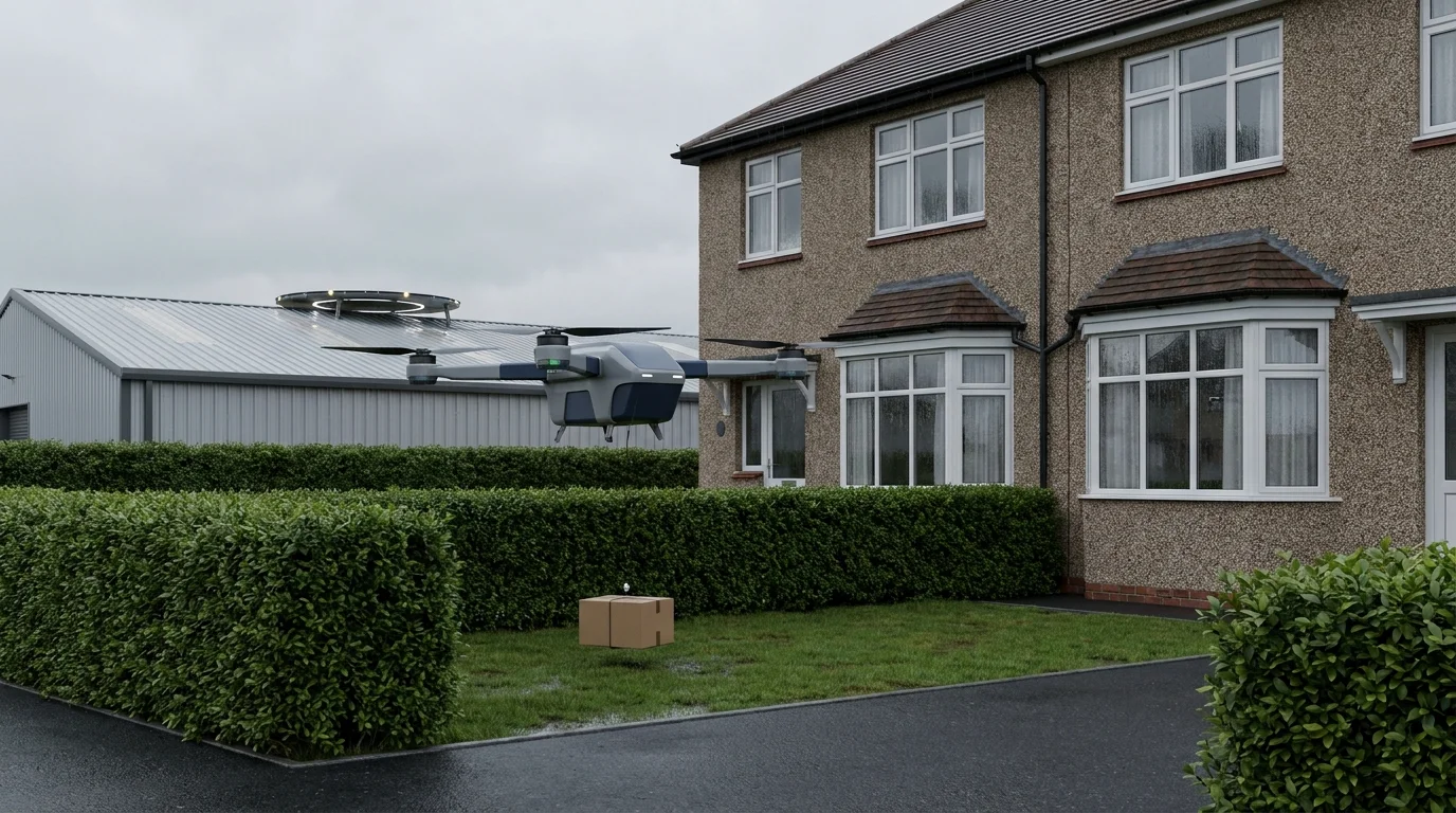
The operational facts a developer needs are simple. The MK30 drone departs from the fulfilment centre and serves customers within a 7.5 mile radius across Darlington and the surrounding parts of County Durham. Each parcel weighs less than 5 lb (2.2 kg). Current delivery time is within two hours, against a US average of around 36 minutes. The cap is up to ten drone flights per hour, or one hundred drone deliveries per day on weekdays. Amazon's MK30 drones run a fixed corridor between the fulfilment centre and the recipient garden, with the drone delivery concept tested at this first site before any UK rollout. The Civil Aviation Authority (United Kingdom) approved the trial until the end of 2026, and Darlington Borough Council granted temporary planning permission on the basis that the scheme was unprecedented.
The site selection logic is worth recording because it constrains where else the model can be replicated. Darlington was chosen because it carries a mix of residential areas, major roads, and an airport (Teesside) within a small geography. Teesside Airport's air traffic control sits in the loop for any non-routine BVLOS coordination. A drone-enabled fulfilment hub on a typical UK industrial estate without an airport adjacency is not a like-for-like replication of the Darlington precedent.
The Darlington consent did not set a permanent UK use class for the typology. Temporary permission was granted because the scheme was novel. A hub at scale, processing more than one hundred drone deliveries per day, will need a permanent consent route, and that route is not yet settled. Other drone deliveries in the UK, including the Borough of Darlington test in England and the Royal Mail Orkney service, sit on similarly bespoke consent arrangements rather than a settled use-class precedent.
Planning Permission and the Use Classes Order Question
The Town and Country Planning (Use Classes) Order 1987, as amended, has no obvious entry for a drone port or for a drone-enabled fulfilment hub. Buckles Law's commercial property analysis sets out the choice clearly: a drone port may sit inside Class B8 (storage or distribution) where storage and distribution remain the dominant use, or it may be assessed as sui generis where the drone operation is the primary planning consideration.
The choice decides the consent route, the conditions, and the permitted-development rights. A B8 reading carries the rights and restrictions of conventional storage and distribution. A sui generis reading requires bespoke conditions: flight-corridor controls, hours of operation, drop-zone restrictions, and noise monitoring.
For a developer, the question is which reading the local planning authority and its planning officer will accept. The lower the share of floor area given to drone operations, and the higher the share given to conventional fulfilment, the stronger the B8 case. A rooftop pad on a 200,000 sq ft fulfilment building reads differently from a 5,000 sq ft drone-only despatch facility on the same site. The CGI must make the floor-area split legible at pre-application stage so the use class is settled before resource is spent on a refused application.
Airspace Evidence: BVLOS, Temporary Danger Areas, and CAP1616
Beyond Visual Line of Sight is the operational category for any commercial drone delivery scheme in the UK. The CAA's BVLOS policy programme sets the route for routine BVLOS operations by 2027. Until that point, BVLOS in Class G uncontrolled airspace generally requires segregation through a Temporary Danger Area or a Temporary Segregated Area. Establishment of either airspace structure requires an airspace change under CAP1616, with a sponsor, a consultation cycle, and CAA approval.
Planning consent and airspace approval run in parallel. Neither creates the other, and a developer briefing a hub in 2026 needs both tracks open early. The CGI brief supports both: an airspace overlay showing the BVLOS corridor across the Ordnance Survey base, and a building-scale viewpoint showing the rooftop pad and ground-level operations. The CAA reviewer reads the overlay. The planning officer reads the building view.
The CAA has authorised commercial operators including Heliguy for BVLOS in atypical airspace, and Egis is advising on UAS, BVLOS, and airspace concept design. These are the reference precedents to cite at pre-application stage when the local authority asks how the airspace question will be resolved. Citing the CAA's published roadmap, CAP3008, and the airspace policy concept page is stronger than relying on a press release about the Darlington trial.
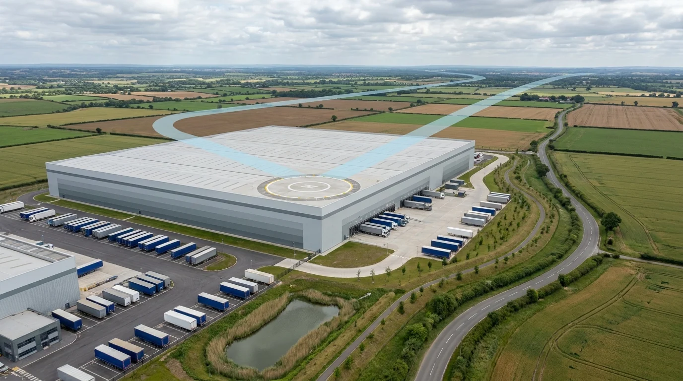
The Rooftop Drone Pad as a Building Element
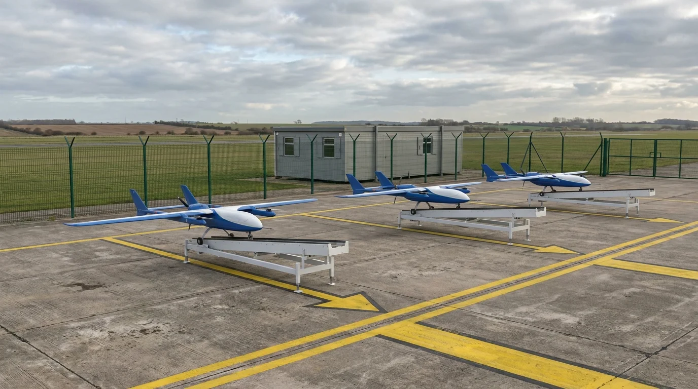
The rooftop drone pad is the new building element a conventional last-mile depot does not carry. Three precedents define how it is being designed in the UK. Marble Arch Place in London, delivered by Almacantar with Skyports and Farrells, places vertiport infrastructure on a residential block as the first commercial drone-delivery destination on a UK residential building. Air One, the UK's first dedicated drone port, uses a fabric tensile structure with a hydraulic FATO platform at the centre that lifts the drone clear of ground-level activity for take-off and landing. Oban Airport's drone-logistics hub uses a more conventional airfield apron arrangement adjacent to existing aviation infrastructure.
For a developer integrating a pad into a fulfilment building, five visualisation evidence questions follow:
- Take-off and landing geometry: FATO footprint, approach and departure paths, rejected take-off envelope.
- Drone parking and battery handling: where idle drones sit, how batteries are swapped or charged, and whether the parking zone is enclosed.
- Weather screening: rotors are sensitive to crosswind and rain, so the pad usually needs a partial enclosure or wind break.
- Structural impact on the roofline: a hydraulic FATO platform changes ridge height as it cycles.
- Plant and services integration: drone operations need power, data, and often a control room alongside the conventional rooftop plant deck.
None of those five questions is answered by a generic rooftop render. The CGI brief must place the camera on the agreed LVIA viewpoint and show the pad in the same elevation as the conventional ridge line, the rooftop plant, and any acoustic screening, so the planning officer can read all the rooftop interventions in one image.
Noise Evidence: BS 4142 Applied to Multi-Rotor Fleet Operations
BS 4142 is the UK standard method for assessing the impact of industrial and commercial sound on residential receptors. The Method Implementation Document on GOV.UK sets out how the rating level is calculated from the specific sound level after acoustic feature corrections. For a drone-enabled fulfilment hub, the assessment must aggregate three sources: the conventional yard, dock, and HGV plant contribution; the rooftop drone pad contribution at landing and take-off; and the cumulative en-route flight contribution at the nearest residential receptor on the BVLOS corridor.
The cumulative en-route contribution is the difficult variable. A single drone flight sits below most BS 4142 trigger thresholds. Ten flights per hour sustained across a working day reads differently. The rating-level calculation must model the time-weighted average and the peak coincident events. A residential garden under the BVLOS corridor at the edge of the 7.5 mile Darlington radius is not the same acoustic case as a garden 50 m from the rooftop pad.
The CGI brief supports the BS 4142 case by mapping the receptor locations on the same base as the airspace overlay, so the acoustic consultant and the planning officer are reading the same geometry. A noise-impact assessment on a different base from the planning CGI is one of the most common reasons drone-hub applications stall at consultation.
Visual and Amenity Impact at the Drop-Zone
Amazon's Darlington model drops parcels into the customer's garden or yard from around 12 ft. The amenity question is whether a low-altitude descent of a multi-rotor aircraft inside the title boundary differs materially from a delivery van at the kerb. Early Darlington reception suggests it does: residents reported they would prefer a parcel handed over, and one described the idea as "nutty as a fruitcake". Quotes are not planning evidence, but they map directly to the amenity grounds a planning officer must consider.
The CGI brief that satisfies the amenity test is built around three viewpoints. The first is the pedestrian eye-line view from the agreed LVIA position, with the rooftop pad in the silhouette and the BVLOS corridor implied by the airspace overlay. The second is the receptor view from the nearest residential garden under the corridor, modelling the descent path and drop event at 12 ft for the 5 lb parcel. The third is the school or play-space view, where the planning officer is most likely to apply the precautionary principle if the visual case is weak.
A landscape and visual impact assessment that addresses the rooftop pad alone, without the corridor and the receptor view, is incomplete for this typology. The same applies in reverse: a drop-zone study that ignores the rooftop massing tells the planning officer half the case. The CGI base model should carry both reads on one geometry.
UK Precedents to Cite in Your Planning Submission
The strongest pre-application submissions for a drone-enabled fulfilment hub cite multiple UK precedents rather than relying on the Darlington story alone. The list below is the bundle a developer can carry into a pre-app meeting in 2026.
| Precedent | Location | What it proves |
|---|---|---|
| Amazon Darlington | Darlington, County Durham | Temporary planning permission for a retail drone delivery hub from a UK fulfilment centre, 2026 |
| Oban Airport drone-logistics hub | Oban, Argyll and Bute | Permanent planning permission for a UK drone-logistics hub at an existing airport site |
| Marble Arch Place | London, Maida Vale | First UK residential vertiport on a commercial mixed-use scheme with Almacantar, Skyports, and Farrells |
| Air One | Coventry, West Midlands | UK's first dedicated drone port, fabric tensile structure with a hydraulic FATO platform |
| Royal Mail Orkney trial | Orkney Islands | Operational BVLOS service across remote-community routes |
| NHS Guy's and St Thomas' blood-supply trial | London | BVLOS in dense urban airspace under CAA approval for a critical-supply use case |
| CAA BVLOS roadmap to 2027 | UK-wide | Regulatory pathway for routine BVLOS in unsegregated airspace by 2027 |
| Use Classes Order 1987 analysis | Statutory instrument | Planning use route for drone ports as Class B8 or sui generis depending on operational mix |
Cite the bundle, not the headline. A pre-application document that names eight UK precedents and references the CAA's published roadmap reads as the evidence base for a permanent consent route. A document that names only Amazon Darlington reads as a request to repeat a temporary trial.
How a Drone-Hub CGI Brief Differs from a Last-Mile Depot Brief
A conventional UK last-mile depot CGI brief models the building, the yard, the van apron, EV charging, and the street-scene at pedestrian eye-line. A drone-enabled fulfilment hub adds two evidence layers that cannot be retrofitted to a depot model.
The first is the rooftop pad and corridor. The base 3D model carries the FATO footprint, the take-off and landing geometry, the drone parking, the weather screening, and the BVLOS corridor as an airspace overlay. The corridor reads on plan and aerial; the pad and rooftop plant deck read on elevation.
The second is the drop-zone receptor view. The model carries the descent geometry at the typical drop height into the nearest residential garden, school, or play-space view, rendered from the LVIA viewpoint position rather than a marketing-friendly elevation. Both layers run on the same geometry as the depot brief, so the same scheme presents as a building, an airspace operation, and an amenity case from one production workflow.
UK Drone-Enabled Fulfilment Hub Questions
What is a drone-enabled fulfilment hub?
A drone-enabled fulfilment hub is a logistics building that combines a conventional last-mile or fulfilment operation with a rooftop or yard-based drone pad for autonomous parcel despatch. The building requires a Civil Aviation Authority airspace approval alongside planning permission, because the take-off corridor and drop-zone footprint extend beyond the title boundary.
Does a UK drone delivery hub need planning permission?
Yes. Drone delivery hubs are not yet a defined use class under the Town and Country Planning (Use Classes) Order 1987. A change of use is usually required, with arguments either for Class B8 storage and distribution or for sui generis classification depending on the operational mix. Amazon's Darlington trial was granted temporary planning permission by Darlington Borough Council on the basis that the scheme was unprecedented.
Is BVLOS the same as planning approval for a drone hub?
No. Beyond Visual Line of Sight authorisation is granted by the Civil Aviation Authority and governs how drones are flown in airspace. Planning permission is granted by the local authority and governs whether the building, rooftop pad, drop-zone, and supporting infrastructure can be built. A drone-enabled fulfilment hub needs both, plus an airspace change under CAP1616 if a Temporary Danger Area or Temporary Segregated Area is required.
How is drone hub noise assessed for planning?
BS 4142 is the standard method for assessing the impact of industrial and commercial sound on residential receptors. For a drone-enabled fulfilment hub, the assessment must aggregate the cumulative dB contribution of multi-rotor flights at peak operations, alongside the conventional yard, dock, and HGV plant contributions. The BS 4142 Method Implementation Document on GOV.UK is the reference for survey methodology.
What does drone-hub CGI need to show that a conventional last-mile depot CGI does not?
A drone-enabled fulfilment hub CGI brief carries two evidence layers a conventional last-mile depot does not. The first is the rooftop pad and corridor, modelled to demonstrate take-off and landing geometry, weather screening, and drone parking to the planning officer and CAA reviewer. The second is the drop-zone neighbour viewpoint, modelled at pedestrian eye-line from the nearest residential garden, school, and road junction to demonstrate amenity impact.
Drone-Hub Visualisation in the Wider Warehouse CGI Workflow
The drone-enabled fulfilment hub sits alongside the conventional UK warehouse typologies. The hub article gives the typology overview and the service page gives the production workflow that supports drone-hub schemes.
- UK Warehouse Typologies Guide The six conventional UK warehouse building types, occupier mapping, and planning-evidence framing.
- Warehouse and Logistics CGI Planning, leasing, and investor deliverables from a single production workflow, including drone-hub schemes.
- Industrial Property Marketing Pre-let campaign image sets, leasing brochures, and occupier-ready portals built from the planning CGI base model.
- Five-Stage Production Process How the planning, BVLOS overlay, BS 4142 receptor view, and pre-let crops are produced from one base 3D model.