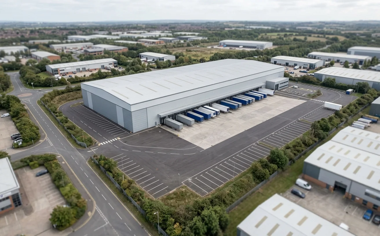
Warehouse and logistics sites
Use verified views to test service-yard massing, approach roads, dock elevations, landscape screening, and views from nearby homes or highways.
Planning evidence CGI
StratumCGI prepares camera-matched verified views and planning photomontage for warehouses, logistics schemes, data centres, industrial parks, and technical facilities where planning teams need a controlled visual record of the proposed change.
A planning image has a different job from a marketing render. It must keep the viewer anchored to a real viewpoint, existing surroundings, and the planning question being tested. StratumCGI builds the 3D proposal against the supplied design information, matches it to the agreed camera, and prepares imagery that helps the project team explain scale, massing, screening, material tone, and likely visual change.
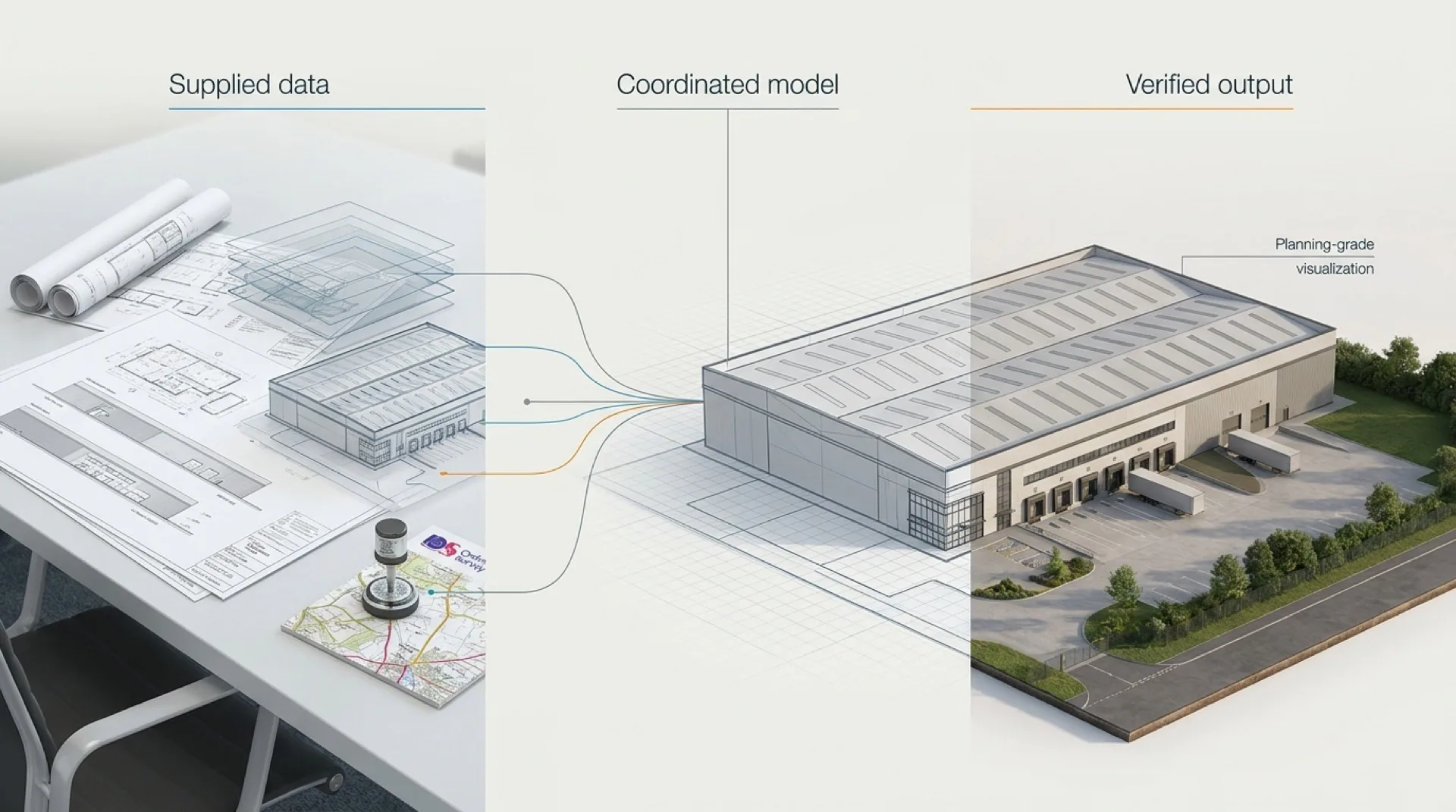
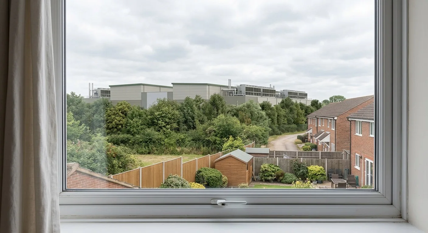
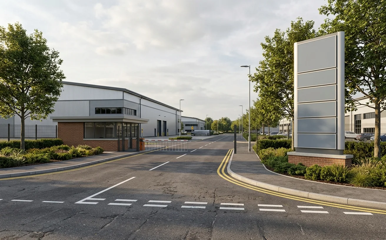
The comparison below uses a site photograph and a proposed development view to show how the page should treat visual evidence: existing context first, controlled proposed view second, with the development shown in relation to road, boundary, people, yard activity, and landscape.
Illustrative example. Final verified views depend on the agreed viewpoint schedule, photographic source, camera information, survey/control data, model accuracy, and the planning consultant's required method note.
The workflow is built around traceability. StratumCGI does not pick attractive marketing angles and call them verified views. The process starts with the planning question, the receptor, and the agreed camera position, then moves into model alignment, material setup, and controlled output.
Confirm who the view is for, why it matters, and whether the viewpoint is set by the planning consultant, landscape team, design team, or local planning authority.
Work from baseline photographs, camera details, site levels, survey/control information, mapping references, and any agreed viewpoint coordinates supplied by the project team.
Build or import the proposed industrial model, align it to the source information, and match the virtual camera to the baseline viewpoint before final material and lighting work.
Issue baseline, wireline or massing, and final photomontage views with the level of annotation, crops, and file formats the planning team needs for submission or presentation.
The writer and build should keep these terms distinct. The page can use AVR and accurate visual representation as supporting language, but the lead offer stays verified views and planning photomontage for industrial developments.
| Format | Use it when | What the image needs to show | Copy boundary |
|---|---|---|---|
| Verified view | A selected viewpoint needs controlled visual evidence. | Baseline context, proposed model, camera match, viewpoint logic, and traceable source inputs. | Do not promise approval or universal compliance. |
| Planning photomontage | The proposal must be composited into an existing view for planning communication. | Existing scene, proposed development, screening, boundary, access, and material tone. | Keep it tied to the viewpoint, not a marketing camera. |
| AVR or accurate visual representation | The project team uses AVR terminology in the brief or methodology note. | Defined level of camera control, alignment, and documentation appropriate to the brief. | Use formal AVR type labels only when the deliverable supports them. |
| Marketing CGI | The same model later supports leasing, investor, or launch material. | Approved geometry with more commercial lighting, occupation, crops, and narrative. | Route broader commercial content to industrial property marketing. |
Industrial planning images often fail when they show only the developer's preferred angle. Verified views need to respect the receptor: a nearby home, public road, footpath, committee viewpoint, landscape edge, or neighbouring occupier.
StratumCGI can work from a consultant's viewpoint schedule or help the design team translate agreed viewpoints into a visual production brief. The assessment itself remains with the planning, landscape, townscape, or heritage consultant where that professional input is required.
A verified-view pack is only as useful as the source information behind it. The table below keeps responsibility clear before cameras, modelling, or lighting work begins.
Planning use, submission context, desired viewpoints, local authority feedback, receptor concerns, and committee or consultation deadlines.
GA drawings, elevations, cladding, roof plant, landscape intent, boundary treatments, and model or BIM files where available.
Baseline photos, camera metadata, viewpoint references, site levels, survey/control points, mapping, and any fixed coordinates.
3D proposal model, camera matching, material and lighting setup, planning photomontage output, review rounds, and file delivery.
The page should stay close to StratumCGI's commercial service lines. These examples show where verified views and planning photomontage belong inside broader industrial CGI work.
Use verified views to test service-yard massing, approach roads, dock elevations, landscape screening, and views from nearby homes or highways.
Show plant screening, building height, secure boundaries, service yards, and neighbour-facing massing without turning the view into investor marketing.
Explain arrival sequence, entrance legibility, multi-unit massing, estate road context, and boundary treatment from the public-facing edge.
The final pack depends on the planning use, viewpoint count, and evidence standard required by the project team. Typical deliverables are modular so one agreed model can support planning first and commercial imagery later.
Existing photography and matched proposed views for each agreed viewpoint, formatted for the consultant team, committee pack, or planning portal.
Intermediate alignment output to help the team review camera match, massing, roofline, and viewpoint logic before final materials are committed.
Image references, viewpoint labels, file naming, and output structure that keeps each receptor and planning question traceable.
Clear crops for public consultation boards, stakeholder decks, or committee presentation where the same viewpoint needs a cleaner explanation.
Once planning evidence views are complete, the approved model can support leasing, investor, and brochure imagery without changing the planning record.
NDA-safe delivery, project reference tracking, and publication control for pre-application, live planning, or commercially sensitive schemes.
Planning visuals can support Design and Access Statements, LVIA or TVIA material, planning committee packs, consultation boards, and pre-application discussion. They should not be written as a guarantee of planning permission.
Where formal methodology is required, the wording should be checked against the consultant brief and the relevant guidance before publication. StratumCGI can prepare the visualisation layer while the assessment author remains responsible for the formal planning, landscape, townscape, or heritage assessment.
These links are context for planning teams, not a blanket claim that every StratumCGI image is formally required or automatically accepted.
A verified view is a controlled visual prepared from a defined viewpoint so the proposed development can be assessed against the existing view. It normally combines site photography, camera-position information, survey or control data, a 3D model, and a matched virtual camera.
A planning photomontage composites the proposed scheme into a baseline photograph for planning communication. A verified view places stronger emphasis on viewpoint control, camera matching, and method so the image can support planning evidence.
Typical inputs include agreed viewpoints, baseline photographs, CAD or BIM drawings, site levels, survey or control information, material references, and the planning consultant's brief for each receptor or view.
Viewpoints are usually agreed by the project team, planning consultant, landscape or townscape consultant, and sometimes the local planning authority. StratumCGI then works from the agreed viewpoint schedule and supplied source information.
Yes, verified views and planning photomontage can support LVIA or TVIA material when the assessment team needs controlled visual evidence. StratumCGI supplies the visualisation layer; the formal assessment remains with the appropriate consultant unless that scope is separately agreed.
No. Verified views and planning photomontage help explain scale, massing, screening, and likely visual change from selected viewpoints, but the planning decision remains with the local planning authority.
Yes. After the planning evidence views are resolved, the same base model can often be reused for leasing, investor, and brochure imagery. The camera logic, lighting, activity, and presentation style change because the commercial images have a different job.
Send the drawing pack, viewpoint schedule, consultant notes, and deadline. StratumCGI will check whether the brief needs verified views, planning photomontage, standard CGI, or a staged pack using the same base model.
The fastest way to scope the pack is to send the current drawings, intended viewpoints, whether the imagery is for pre-application, submission, consultation, or committee, and any guidance from the planning consultant or local authority.
Email: hello@stratumcgi.co.uk
Request a Quote